


Best Price
$34.99
Notes
- To purchase, click Add to Cart button above. A new tab (Amazon.com Page) will open. Press Continue button to checkout there.
- If you want more detailed information, you can view it here.
Product Photos
Product Descriptions
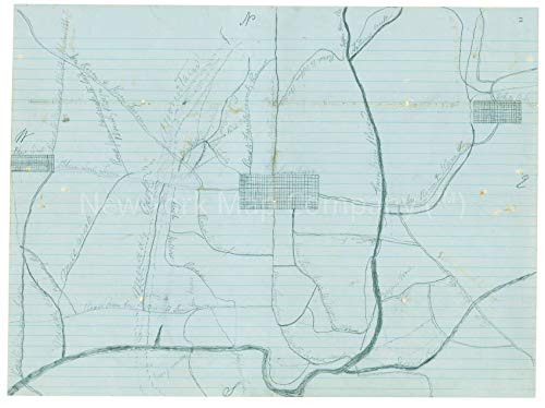
1862 Map|Title: Map of a part of Greenbrier County, West Va|Subject: Civil War|Greenbrier County|Greenbrier County W. Va|History, Manuscript|West Virginia Notes: Drawn with pencil and ink on blue-lined paper. Shows towns, roads, rivers and mountains. Not drawn to scale. One of a series of eight maps of southwestern Virginia and West Virginia. Originally in envelope with notations: "Maps of various kinds by residents of western Virginia. Found among a few books &c which had belonged to Genl. Loring. This statement made by Mr. John Hart." Oriented with north to the top. Relief shown by shading. Shows Lewisburg, W. Va. and the surrounding area.Map Size: 18 inches x 24 inches |Fits 18x24 size frame (or 18x24 Mat Opening)|Frame not included
Title: Map of a part of Greenbrier County, West Va.
Subject: Civil War|Greenbrier County|Greenbrier County W. Va|History, Manuscript|West Virginia
Notes: Drawn with pencil and ink on blue-lined paper. Shows towns, roads, rivers and mountains. Not drawn to scale. One of a series of eight maps of southwestern Virginia and West Virginia. Originally in envelope with notations: "Maps of various kinds by residents of western Virginia. Found among a few books &c which had belonged to Genl. Loring. This statement made by Mr. John Hart." Oriented with north to the top. Relief shown by shading. Shows Lewisburg, W. Va. and the surrounding area.
Map produced on Fine Art Matte Paper (230g, 14mil) that maintains vivid colors and faithfulness to the original map. Archival Quality reproduction guaranteed not to fade for 200+ years.
Customer Reviews


This post have 0 comments
EmoticonEmoticon